LE MOUSTEIRET. Ruine Chalvet .Col de l Escuichiere . Le Villard o m s

RobinMicheline
User GUIDE
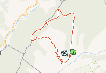

Length
10.1 km

Max alt
1263 m

Uphill gradient
539 m
Km-Effort
17.3 km

Min alt
733 m

Downhill gradient
564 m
Boucle
Yes
Creation date :
2020-03-13 10:22:12.002
Updated on :
2020-03-13 17:45:25.839
3h25
Difficulty : Medium

FREE GPS app for hiking
 SityTrail
IGN / Geographical institutes
SityTrail Plus
The world is yours!
About
Trail Walking of 10.1 km to be discovered at Provence-Alpes-Côte d'Azur, Alpes-de-Haute-Provence, Le Brusquet. This trail is proposed by RobinMicheline.
Description
Bien
Photos


Positioning
Country:
France
Region :
Provence-Alpes-Côte d'Azur
Department/Province :
Alpes-de-Haute-Provence
Municipality :
Le Brusquet
Location:
Unknown
Start:(Dec)
Start:(UTM)
283738 ; 4894292 (32T) N.
Comments